Introduction
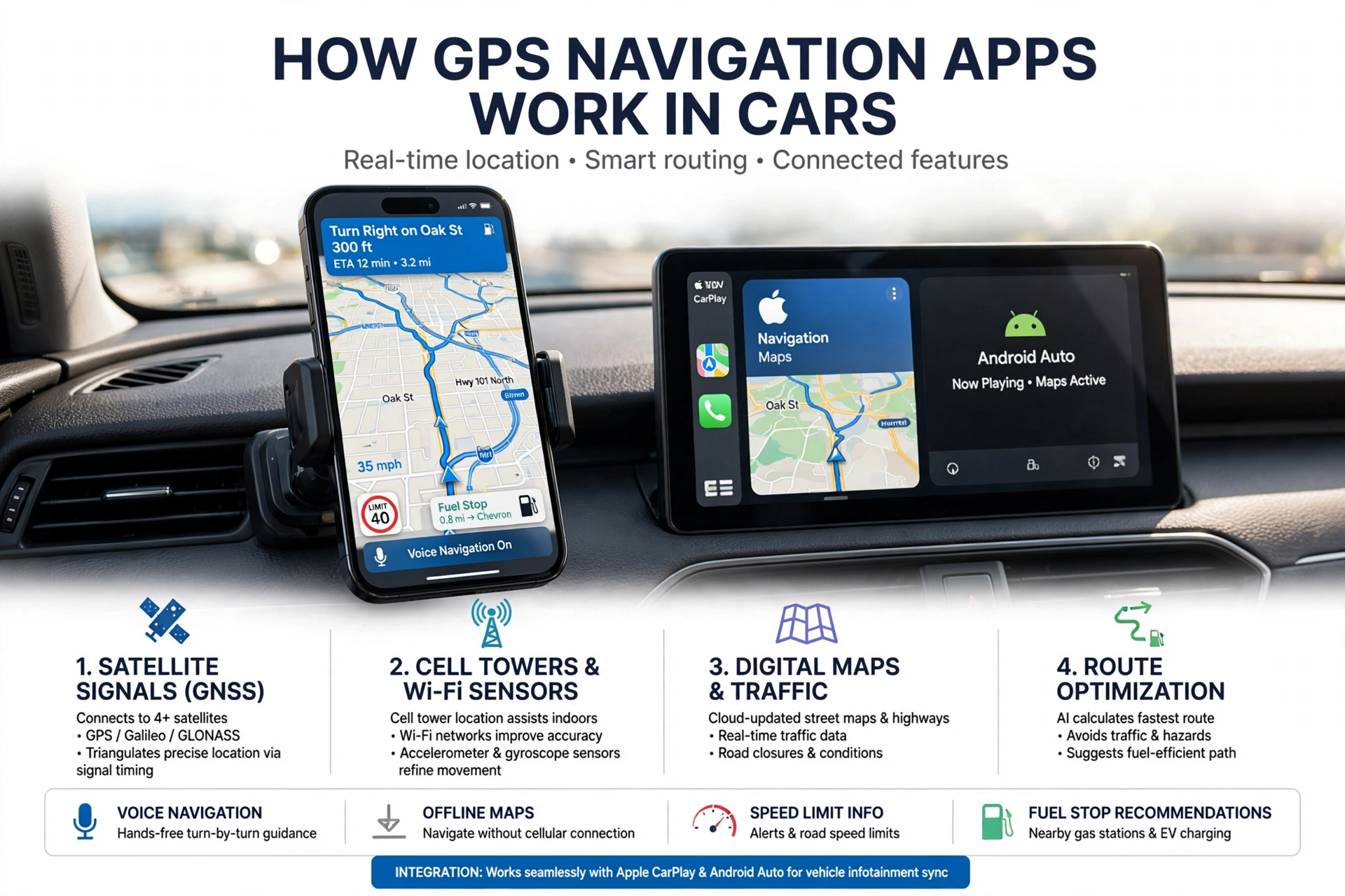
GPS navigation has become a staple of today’s travel. Out of the paper maps and basic nav devices we had in the past, we now see drivers using smartphones and vehicle info systems which provide directions, traffic info, speed which is posted at the side of the road, and also which gas stations to stop at. Also, these apps, which run on satellite technology, digital maps, internet access, and software which does the heavy lifting, determine the car’s location and which route to take.
Understanding which technologies GPS navigation apps are based on allows drivers to pick out one that best meets their requirements. Key features are real-time traffic, route optimization, voice navigation, offline maps, speed limit info, fuel stop recommendations, and smartphone and vehicle integration. A good navigation app will present accurate info yet also be easy to use in the day-to-day drive.
How GPS Navigation Apps Determine Location
GPS navigation starts out with satellite signals. A smartphone or car navigation system picks up signals from multiple satellites, which it uses to determine the vehicle’s location. Also, today we see that many devices which use GPS also, at the same time, use cell towers, Wi-Fi, and inboard sensors to better define the exact location of the device, which is very useful in situations where the satellite signals are weak.
Upon determining the vehicle’s location, the navigation app looks up that information in the digital map. This allows the app to determine which road you are on as the journey is in progress and also to update position as the drive continues. If the driver misses a turn, the app will detect this error and put forth a new route.
Digital Maps and Route Optimization
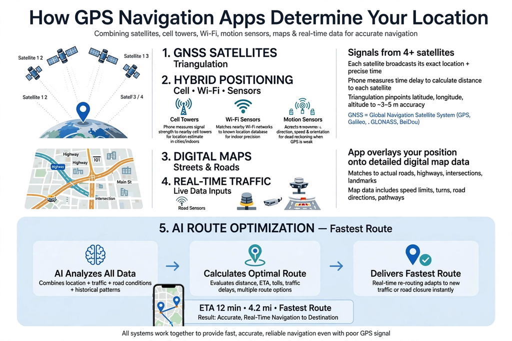
Digital maps present the info which navigation apps use to develop directions. They may include streets, highways, intersections, road names, one-way roads, restrictions, fuel stations, parking areas, and other points of interest. As roads change, so do the maps, which is why they require regular updates to stay useful.
Real-Time Traffic and Dynamic Routing
Real-time traffic reports which navigation apps use to identify gridlock and variable road conditions. We see that info coming from road sensors, transport authorities, connected cars, user reports, and location data. Also, the app will present this info to you and use it in the route calculations.
Dynamic routing is a feature which changes as conditions do. For example, if there is an accident which causes heavy traffic ahead, we may be directed to a different route. This can save time, especially during peak hours, although traffic predictions aren’t always accurate.
Voice Navigation
Voice commands for navigation are available to drivers so they don’t have to take their eyes off the road or the infotainment screen. The app will announce upcoming turns, road names, exit information, and other key details. At complex intersections and highway exits, clear direction is very helpful with this feature.
Some navigation systems also feature voice commands, which allow drivers to search for destinations or put in a route without the use of a keyboard. Also, we have phone and car integration that will pass along those requests through the car’s speaker system, which in turn makes the navigation easier to operate while on the go.
Offline Maps
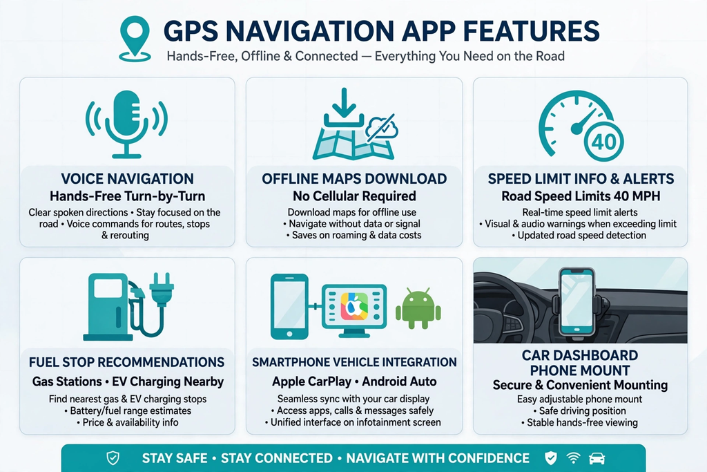
Offline maps are a great option for when drivers go into areas which have poor internet access. Before a trip, users may download the maps and will still have access to basic turn-by-turn directions with no internet connection, which in turn is very handy during long-distance trips or in out-of-the-way areas.
However, we see that there are issues with offline navigation. Real-time traffic reports, present road closures, and certain search features require you to be online. Also, what users download of the maps may become outdated, which is why it is recommended to update them regularly.
Speed-Limit Information
Many navigation apps present what is to be the speed limit for the road which you are on. Also, some systems will alert you if you go over the posted limit. This may prove useful in areas that have many speed limit changes.
Drivers must follow what the official signs say, as digital info at times may be out of date or incorrect. Also, note that speed limit info is a handy addition, but do not count on it completely; instead, pay attention to the road.
Fuel-Stop Recommendations
Fuel locations which we have identified for you along your travel path can be found through navigation apps. Instead of a manual search, you can use the nav app to find the nearest fuel-up points, which in turn may also present a choice of which station to go to or if a detour is necessary. Also, some apps may include info on the type of fuel and price at the stations.
Similar in that we are seeing features which now play a role in the electric vehicle space, for instance, navigation systems which in turn help in the search for charging stations. Also, within navigation apps, we see that drivers are using them to find out information on restaurants, parking areas, rest stops, repair facilities, and other services which they require during a trip.
Smartphone and Vehicle Infotainment Integration
Today’s cars are equipped with technology that interfaces with smartphones, which in turn puts nav apps right at your fingertips on the car’s bigger screen. Also, you can have navigation info read out through the car’s speakers and control it via the steering wheel buttons or with voice commands.
This integration improves that you may use your favorite smartphone apps which you are already familiar with while you are driving. What we have is variable compatibility between phones and cars, which is to say that not all systems are supported in all vehicles. It is best that you check which of the systems in your car are supported before you choose which app to use.
Features Drivers Should Look For
Drivers, when choosing between GPS navigation apps, should look at what they get in terms of practical benefits. What is key is accurate and up-to-date maps, which should be a given. Also, real-time traffic info is a plus for those that log a lot of miles in heavy traffic. Also, what you want to see is a system that is able to reroute when traffic reports change.
Other features which prove useful are voice navigation, offline maps, speed limit info, fuel stop recommendations, and smartphone and vehicle infotainment integration. Also, drivers should look at how easy the app is to use, how often its maps are updated, and how good its traffic info is in your area.
Conclusion
GPS navigation systems use satellite positioning, digital maps, traffic info, and route planning tools to get you to your destination faster. Today, we see that beyond the basic function of direction, they include dynamic routing, voice guidance, offline maps, speed limit info, fuel stop recommendations, and also integration with smartphones and vehicle infotainment systems.
In terms of navigation apps, when I purchase as a driver, what I am looking for is, in the main, very accurate service, which is also very reliable, easy to use, and includes features which play to my normal driving issues. Also, what I want from a good nav system is that it gives out useful info but, at the same time, does not overcomplicate things or be a distraction. As we see connected vehicles and map tech growing, which they are at a very fast pace, we are going to see GPS navigation play an even larger role in our daily commutes.


The article presents a clear perspective on the topic during my research and I look forward to reading more from you