Today’s navigation systems go beyond the functionality of helping drivers navigate from place to place. They can provide the user with information on road conditions, predict delays, and recommend alternate routes when the default route is congested. This is made possible by the use of navigation systems that have a combination of GPS location data, past traffic patterns, road sensors, user reports, traffic accident data, construction data, and computer algorithms. These sources combined create an ever-evolving view of traffic and the time of the trip along various routes.
Real-time navigation can be updated along the way, which differs from traditional maps. A road that’s clear when a driver heads for the road can suddenly become congested minutes later due to an accident, construction, or a sudden surge of traffic. If new information comes in, then the application can recalculate and see if it could be faster to take another route. This is also the reason why drivers are sometimes unable to follow the directions of their navigation app after they have already begun driving.
What Is Real-Time Traffic Navigation?
Real-time traffic navigation provides the driver with the most up-to-date information about the road for planning the best route. The system doesn’t just find directions based on distance and normal driving speeds, but also takes into account how traffic is moving. When vehicles are moving at a specific speed along a specific road, the application can adjust the estimated speed of the road and then determine the difference in travel times between the road and other available roads.
The system can also continue to monitor conditions after the journey. The application can maintain the original route if the traffic has improved. If congestion gets too bad, however, or a new incident occurs, it may be able to recalculate the route. This helps to make the navigation smoother as the suggested route may vary depending on the road’s condition.
Traffic Congestion and Navigation Applications
Traffic congestion is a major obstacle in road navigation. Some of the biggest challenges in road navigation are traffic jams.
This is how traffic applications determine traffic congestion and involves the integration of several information sources. Smartphones using GPS can be used to gather data on how vehicles are moving, and navigation systems can predict the speed for various roads. There are situations where the system can identify congestion occurring when a large number of devices are travelling at low speeds along the same road. This data can then be used to compare typical traffic speed for that time and place.
The ways in which navigation maps identify congestion involve several sources of information. Navigation applications identify traffic congestion by combining GPS information with other available traffic data to build a clearer picture of what is happening on the road.
GPS Location Data and Traffic Speed
GPS location data is one of the biggest sources utilized by navigation systems. Smartphones can also calculate where they are and how they are moving; the navigation providers can then determine how the devices are travelling on streets where they have navigation maps. The system can calculate the average traffic speed when multiple devices are aggregated, and it can detect traffic conditions with reduced speed and traffic stops.
This information is also used to compute travel times. A road can be several kilometres long, but the length of the road is not sufficient to indicate how long it will take to travel. When the traffic flow is slow, the estimated travelling time will be higher. The navigation system can also recalculate the expected arrival time as the speed of traffic fluctuates and decide if another route would be more efficient.
How Navigation Applications Detect Traffic Congestion
This is how navigation applications detect traffic congestion and involves the integration of several information sources. Smartphones using GPS can be used to gather data on how vehicles are moving, and navigation systems can predict the speed for various roads. There are situations where the system can identify congestion occurring when a large number of devices are travelling at low speeds along the same road. This data can then be used to compare typical traffic speed for that time and place.
GPS data is particularly valuable since it provides an indication of vehicle movement and not just the location of roads. The system has evidence that traffic conditions have changed if vehicles typically move at a high speed on a highway, but a large number of devices begin to show slower speeds. This data can be used in conjunction with road sensors, accident reports, construction data, and user-based reports to build a more accurate traffic picture.
Historical Traffic Patterns
Historical traffic information over a long time period is also used for navigation applications. People like to have similar travelling times, and this can create the impression of regular traffic. Traffic is usually heavy during rush hour in the morning and evening, and weekends can have different hours of traffic. Historical information is used to help the system know what is normal for a specific road and time.
When there is currently limited information, this data is very valuable. The system can have insufficient live information to make a good estimation if the number of devices travelling along a road is limited. History can give a baseline and a forecast of what traffic patterns might be later in the trip. So, navigation apps rely on both what is currently happening and what typically happens at this moment.
Road Sensors and Traffic Infrastructure
Information from the traffic-management infrastructure can be utilized by some navigation systems. Sensors could be placed on roads to track traffic, vehicle speeds, or other factors, depending on the region. Another source of information regarding congestion, road closures, and major incidents is traffic cameras and transport agencies. These sources can provide navigation services with extra information beyond the information smartphone GPS provides.
Road sensors, however, do not exist in all locations. There is a wide range of road traffic monitoring infrastructure, with some having a lot and others having little. That is why navigation apps typically fuse their sensors in with GPS data, historical patterns, and more. It is easier to identify traffic problems using multiple sources because there might be limited information available from one source.
User-Generated Traffic Information
Also, drivers can input details through navigation apps. Users can report incidents, partially blocked traffic, hazards, road closures, etc., depending upon the service. These reports can be used to find incidents that automated traffic systems might not be able to comprehend at the moment. If, for instance, a motorist has spotted a blockage that hasn’t been expected, they can alert other drivers in the area of the blockage.
User reports are useful because they can help give context. The navigation system might detect the sudden halt of vehicles, but driver reports may point to an accident resulting in the delay. Sometimes, however, reports are incorrect or even out-of-date. Navigation services can then use this information to make comparisons with other traffic signals and use this information to impact route suggestions.
Unexpected Delays and Accident Reports
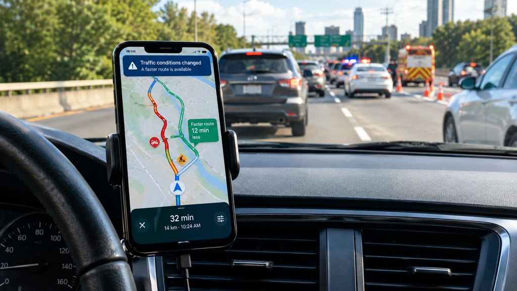
Accidents can result in significant traffic delays that may involve traffic lane closures or a reduction in traffic speed. User reports, transportation authorities, and changes in the movement of the vehicles can all provide the navigation application with information about accidents. In case the incident is detected, the system can determine the amount of extra time it may introduce on the routes in the vicinity.
It can change over time how an accident will affect you. If a newly reported accident causes congestion to increase rapidly, or an older accident may be clearing, the congestion may increase or decrease rapidly. Hence, navigation algorithms take into account the delay as well as the potential for changes in the conditions. The system might suggest another road if the anticipated length of time grows significantly.
Construction Areas and Road Closures
Even if there is no primary traffic jam, construction can have an impact on navigation. Roadway closures and/or slowed traffic speeds may occur, roadway access may vary, and/or a roadway may be completely closed. Construction data can be sent to the navigation services, and the services are able to utilize the construction data to compute navigation routes.
The application also may be able to compare construction information with traffic movement. If the road is “under construction” and GPS data indicates that vehicles on that road are travelling unusually slowly, there is a greater likelihood that the construction is impacting traffic. This can help the application not to route drivers towards a known restriction.
How Algorithms Estimate Travel Time
Navigation algorithms use the map information to split up a route into sections of the road and to make an estimate of the time required for each section. Current speeds, historical traffic, road attributes, accidents, construction, and other available information can be included in these calculations. The travel times for each road segment are then added up to arrive at an estimated travel time for the whole trip.
Travel-time prediction is difficult because the traffic may be different when a driver is on the road. There can be clear parts of a route, but congestion in other parts. The system must take into account various situations over the entire path and predict what they might be as the driver arrives at each section of the path. This enables it to consider different possible paths and not just the shortest path.
Why Navigation Apps Change Routes During a Journey
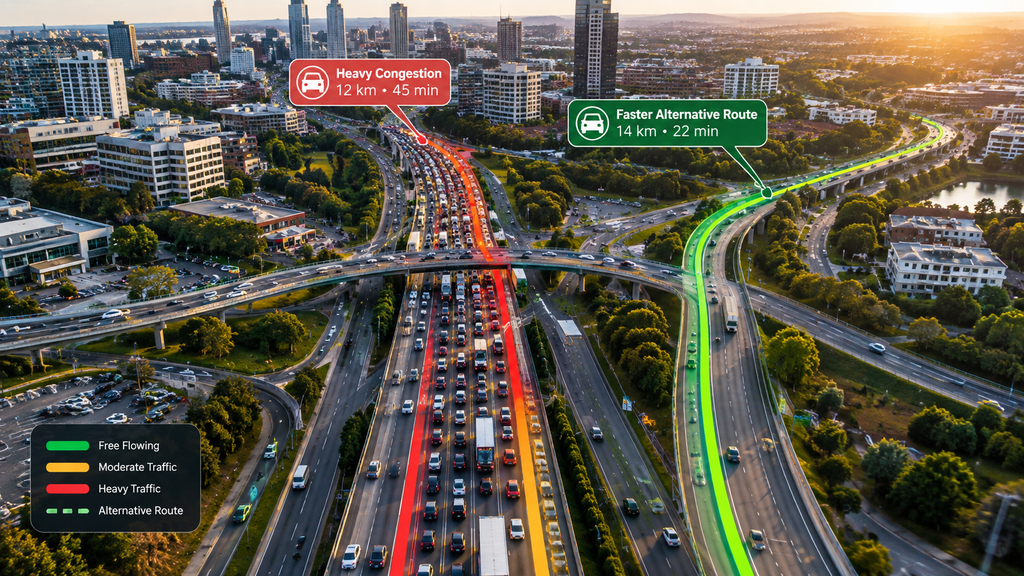
If new data becomes available that a different route might be preferable, a navigation app will adjust its route. The original route was figured based on information at the time of the journey. In the event of an accident following or congestion being greater than projected, the travel time on the original route may be extended.
The change of a route does not negate the fact that the original recommendation may have been good. Traffic is subject to constant change, and the fastest route at any time could not be the fastest at a later time. Recalculating will enable the application to react to new information. Drivers should, however, use their common sense and obey road signs and local traffic directions.
Real-Time Navigation and Its Potential for Saving Driving Time
Real-time navigation can help avoid major delays, thereby saving drivers driving time. If the system senses congestion or an incident ahead, it is able to calculate alternative roads and decide if another road may save time. Avoiding one major traffic jam can make a big difference to the journey.
The system can also alert drivers to avoid travel on roads that are known to be problematic from an accident, closure, or construction point of view. But it is dependent on the quality and freshness of the information available. Navigation routes can be unpredictable, and no navigation program is 100% accurate. Real-time navigation should then be considered as helpful guidance instead of the quickest path to take.
The Limits of Real-Time Traffic Navigation
Real-time navigation is great, but it is not infallible. Information cannot be collected and processed as quickly as the traffic situation can change. Conditions and occurrences that are not accurately forecasted by historical data can arise suddenly, due to such factors as major events, severe weather, unplanned road closures, and accidents. GPS data can also be inaccurate, and user reports can be incomplete or inaccurate.
The quickest route calculated cannot necessarily be the optimal route for each driver. Others might opt to take the main roads rather than the toll roads, or even take the easier road even though the other is marginally quicker. Some preferences may be taken into account in navigation applications, but still, recommendations rely on information and predictions.
Conclusion
Real-time traffic navigation is based on the merging of data from GPS, traffic history, road sensors, user feedback, accident data, construction information, and algorithms used to calculate travel time. The different sources give different information, which lets navigation systems get a better idea of the road’s current conditions and what to expect.
If the app updates a route as part of a journey, then it is likely that it is reacting to new traffic data. An incident, increasing traffic, a construction issue, or the predicted travel time for a route can make another route more efficient. While they can’t stop traffic or foresee the future of road events, these systems can continually assess road conditions to help drivers avoid delays and make informed travel choices.